Showing posts with label Karnataka. Show all posts

October 31, 2012

Meandering Among Ruins And Memories In Bijapur


A snake lay flattened on the road. Using a stick I found in the brush roadside I turned it over to see if I could identify it. I couldn’t. It was flattened to its skin, scattering scales around, making identification ever more difficult more so since I’m no expert on snakes.

Ahead, the Ring Road sloped and ran straight before curving out of sight; later in the day we would ride it on our way to Torvi, past Navraspur. Trucks droned up the incline, shattering the silence in the countryside that’s gradually losing its quiet and open expanse to an expanding population radiating outward of the city centre – Bijapur.


I stepped past the twisted figure, a sign of a last act of desperation as it drew its body close upon suffering the first impact before suffering another, and another. Time came at it like a sledgehammer practicing its blows. In its death it had frozen its attempt at clinging on to life.


Crunching gravel we walked to remnants of an old stone structure a little distance away, an imposing stone gate that stood all by itself.


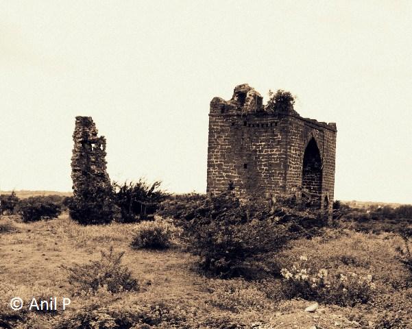
To the left of the gate a crumbling edifice stood unsteadily, likely a remnant of a wall that extended from the gate. Very little remains of it to help identify its function positively. The structure of the gate itself has survived well with the exception of battlements surmounting its roof.

I wonder if the rooftop battlements, of which only a hint now remains in the surviving embrasure to one corner of the roof, were merely decorative elements or formed a part of an active defensive line extending along walls from the gate, guarding its approach. Grass spouts through the lone crenel, obscuring it to all but a persistent eye. I notice a crumbling fortification at the same rooftop corner as the surviving battlement. A turret? A resting place? A control room? I cannot tell for sure.

Wildflowers grew among thorny bushes, relieving the stark landscape that stretched flat northward. The great plains of the Deccan stretch a long way. Winds play in the open expanse, winds so strong they'll knock the unwary off their footing.  


Bijapur is a city of monuments, in ruins or otherwise, together stringing a history under Muslim rule that was both bloody and uplifting. The city itself traces its pre-Islamic history to the reign of the Hindu Chalukyas, the Yadavas, and the Sangamas of Vijayanagara before Islamic invaders took the sword to them.


The old, arched stone gate rose high over me. I walked through it not knowing if I was entering the gate or exiting it as I made for a mound past it, but most likely exiting it. From the mound I hoped to get a better view of the Bijapur countryside that lay not far from my cycling route from years ago. A masjid, visible through the gate, stood on rocky ground a little distance away.

Madhav and I were on our way to Navraspur, and beyond, to the temple at Torvi, a permanent fixture on my periodic visits to this part of Karnataka, a ride I hoped would relive memories from long, long ago for, finding myself in Bijapur during vacations from school I would mount VRN’s bicycle and head out on the NH 12, better known as Athani Road, for Torvi over six kms. away.

VRN has since passed on to the great beyond, and the city I first experienced as a toddler clinging on to his cycle’s handlebars, legs crossed under me as I tagged along with him around the city, one that I can no longer imagine without its association with VRN survives to tell its tales in the many monuments in disrepair within its fort walls and outside, the latter in the general direction of Navraspur, structures that were at one time likely a part of a grand design Ibrahim Adil Shah II sought to construct at Torvi after removing his seat of governance in 1604 from the citadel in the old city to new fortifications underway around Navraspur and Torvi. Among others they included palaces, and water tanks that were as much architectural marvels as they were lifelines supplying Bijapur, and the ill fated new city, with water.

Only the new plan never saw fruition, the new seat of governance near Torvi was razed to the ground and plundered by Malik Ambar in 1621 A.D. Abandoned, the seat of governance returned to Bijapur’s old citadel never to leave it again. Ibrahim Adil Shah II died soon after.
~

It is September; the sparse rains that come Bijapur’s way in the north of Karnataka have given way to clouds marching in the sky, turning the light a heavy shade of gray, and the atmosphere, sombre.


Rather than continue to Navraspur and Torvi on Athani Road (NH 12) straight west that goes on to Belgaum via Athani, Madhav and I turned off it, onto Solapur Road after taking a right soon after the road breaches the Adil Shahi era fort near the bastion named Sherza-i-Buruj (Lion Tower) where the medieval monster of a canon, the 55 ton Malik-e-Maidan (Lord of the Plains), sits in splendid isolation, pointing West at the horizon from whence Bijapur’s enemies once threatened it.


The canon, a star attraction with locals and visitors alike, was a war trophy carted back to Bijapur by Ali Adil Shah after vanquishing Nizam Shah in 1562. At over 4 and ½ metres, the Malik-e-Maidan is said to be the largest battlefield bell metal armament ever cast in its time by Muhammad Bin Husain Rumi in 1549 AD in Ahmednagar as noted by an inscription on the canon.


If not for the railing fencing off the viewing enclosure I’ve little doubt that inquisitive visitors would attempt to slide down its barrel, comfortably fitting into the opening 1 and ½ metres wide.

Its sheer bulk weighing in at a staggering 55 tons is said to be the key reason why the British did not steal it out of India as booty given the cost of transporting it to the coast after first considering sending it to the King of England in 1823. It was just too big a loot to carry, else like with other loot gracing British Museums, the Malik-e-Maidan would’ve likely occupied a corner in a far removed from the landscape.


Leaving Athani Road (NH 12) after taking a right turn, we rode along Solapur Road before turning off it, onto Jatt Road, riding past Darga Jail, Khwaja Ameenuddin Chisti’s Dargah, and Phani Parshwanath Jain temple, eventually joining the Ring Road near where the snake lay flattened.

The Ring Road circles back to Athani Road shortly before Navraspur; Torvi lies a short distance further on. Over the years, I’ve ridden both, the Athani Road and Solapur Road out of Bijapur on my way to Belgaum, and occasionally Solapur. In daytime, early morning to be precise, the Deccan landscape makes for a pleasing ride.  

The customary ride to Torvi is as much a homage of sorts to the rite of passage that cycling from the city centre to the then sleepy village six kms away once was as it is a tradition for, the Narasimha temple built underground and to reach which one has to navigate a short dark passage chanting “Hadhey, Hadhey” is of particular significance to my family, and hence to me. My mother would never fail to remind me to chant “Hadhey, Hadhey” (make way, make way) as we negotiated the underground passage that leads to the sanctum sanctorum.    

On my way to Torvi astride VRN’s bicycle, the Atlas type, I would pause on rutted roads that ran past views similar to that in the picture above, wondering about them.

There was little or nothing to identify their origins except they were a permanent fixture in the landscape from as long back as anyone could remember, atleast among those I ventured out with, Jai among others. The mullahs with their thick black beards extending at an angle from large jaws set off by piercing black eyes were a tad intimidating at any rate and as a kid I knew better than to tangle with their lot, helped no doubt by several intimidating experiences in the community they served and lived.


I wondered after the purpose of the gate towering before me. Madhav meandered around it. Two women sat in front of a disused masjid on a mild elevation a little distance away, muslim women tending goats foraging in the brush around. 


On a subsequent visit a year later, again with Madhav, passing cowherds would identify the masjid for me as Dharyali masjid.

“It’s no longer used now,” one of them would say in a sing song Kannada dialect peculiar to Muslims from North Karnataka.


The same man, pointing his stick to the apparently mysterious gate I now beheld would identify it as Pani Darwaza (Water Gate). “In those days water would flow through it from there,” he said, showing me the path the water took before pointing through the gate, past the Dharyali masjid, to the open expanse behind, indicating the direction from which the water flowed. Further exploration in the direction he pointed out reveals what appears to be remnants of a masonry construction, probably belonging to the reservoir. Again, I cannot be sure if the reservoir brought its retaining walls this close to this gate. A large reservoir once existed at Torvi, of that I'm certain. Maybe it still does.

The gate could not possibly have been built as a conduit for water. As an approach to the reservoir, likely, but surely not as a water channel. It had to be a part of fortifications if not an embellishment.  


There was little to indicate with any clarity except possibly to those who’ve lived there and heard stories passed on from generation to generation.

Behind us, in the general direction from where we came, in a similarly ancient patch of the countryside, a massive stone structure lies in disrepair, figuring in some significant way with water works the Adil Shahi kings effected to supply Bijapur city with water drawn from the reservoir located near Torvi over six kms. away.

On another visit many, many years ago, I had made my way to the abandoned structure, marvelling at its scale and architecture, wandering through it while wondering not so much as to its function of which I was aware but about how it must’ve functioned in its day, and the thought behind its architecture. I wonder still. 


In time the Adil Shahi reign came to be known for innovative engineering to put in place secure water pipelines to supply the city, including underground water channels carved in rock and interspersed with chambers and inspection holes, control towers, water cisterns, wells, ponds, and the many water tanks that dot the city, most notably the Taj Bawdi and Chand Bawdi, each an exercise in lending regal splendour to their purpose, a place to bathe and draw water from, a space to seek respite from the sun.

~

Apparently little has changed in the patch of landscape we had stopped by to wander about. The gate’s arch frames a masjid behind.   

No wall led from the gate. There was nothing to indicate where the gate led in the days gone by except for overgrown thickets crowding tombs and a mosque where men in skull caps sat chatting in a corner.


From the mound we ascended for a better view of the countryside, two more structures revealed themselves a little over fifty yards from the arched gate and Dharyali masjid. One appeared to be a mosque with two minarets, the other, most likely a tomb, or maybe both were tombs though I cannot recollect seeing one with minarets.


Zooming in I could see men in skull caps gathered to one corner of the platform that conveyed a passage around the main chamber walled off on the side facing us.


Two Muslim women emerge from the thickets along a dirt path winding between thorny bushes, past the dilapidated monuments I now viewed through my lens.


For a fair distance to the north, nothing moves. Slowly the landscape converges to a canvas, securing the feelings it invokes, into colours turned sombre from the weight of history and ignominy heaped by an uncaring present.

Except for a wooden triangle with notches I find lying centered on the approach to the arched gate that Madhav said was most likely an implement used in performing Black Magic, one that he forbade me from picking up, there was little sign of life about the place except for a black goat grazing in the thorny shrubs.

It might have as likely been an instrument used in accompanying the dead to their burial places. I cannot be sure except, on my subsequent visit to the same place close to a year later, Madhav and I found two sets of stones heaped on the approach to the arched stone gate in the manner of burial mounds, and were more likely than not  graves of fairly recent origin. Graves at the gate? Whose? Why here?

Bijapur has always posed me more questions than answers, retaining its mystique and mystery in unanswered queries.


Walking back from the arched gate, we continue along the Ring Road and circle back to Athani Road (NH 12) before continuing to Torvi, past Navraspur.

I will tell of Torvi another time.


July 23, 2009

Talacauvery, Stairway to the Heavens


No one told me there was a stairway in the Brahmagiri hills that led up to the heavens, to the gods, well almost.

The most I had imagined of Talacauvery when we left Bhagamandala for the hills was a pilgrim centre not very different from the many dotting the countryside, drawing urgent pilgrim feet into traveling long distances to pay obeisance as much to the deity as to the faith of their forefathers. At Talacauvery the river Cauvery emerges as a perennial spring before strengthening into one of India’s mightiest rivers revered as one of the Sapta Sindhu or seven holy rivers and is considered to be the Ganges of the South.


In the time it took the bus to inch up the winding road in the hills to the birthplace of the Cauvery eight kilometers away, alternating between blind turns cut in the side of the hill and steep drops that descended rapidly to the plains below, my picture of Talacauvery was complete. I had imagined it. Now I only had to retrace my memory map once we arrived at Talacauvery to recognize the familiar contours I had never once seen before except in the urgency of my anticipation of the sojourn in the hills.

The Talacauvery I had imagined while I sat alongside the driver in his cabin, looking out the windshield at the narrow ribbon of a road stretching ahead, lay hidden from easy view in the forests of the Brahmagiri hills. The steep climb up the hill would have ensured not merely her sanctity but the integrity of her surroundings as well, beyond the easy reach of anyone but the most faithful of her devotees, certainly spared of those stopping by to dip their feet in the sacred water while on their way elsewhere. The elsewhere at Talacauvery ended in a steep drop of several hundred metres.


After all the Cauvery had chosen to break surface in the heart of the Western Ghats mountain ranges and it was only fitting that she surfaced to the silence of the jungle, punctuated by calls of birds flitting from branch to branch in the shade of trees where time moves to the whims of the divine and to the necessity of nothing.

However the reality as I was to soon find out on reaching Talacauvery was very different from what I had imagined. Shorn of any green cover we came up against an ostentatious looking arch under construction, presumably a praveshdwar (gateway) the kind I would imagine gracing erstwhile kingdoms with the architecture to carry it off, not the source of a river.


A viewing platform built on the edge of the hill swept over tiled homes below. A road passed houses as it wound its way through the trees. There was no one on the road. In the distance folds upon folds of mountains receded, nudged back by a fair way until the farthest mountains became faint outlines of blue, merging with the sky. Physical perspectives merge into one in the distance, the same cannot be said for those of the mind. I let the nip in the breeze pull my imagination free and sweep it away, toward the mountains.

Joy’s call cut my flight of thoughts short. It was time to pull away from the panorama and turn to the gateway and beyond. Matters of religion and faith beckoned and there was little time to spare.


Beyond the gateway a large open platform stretched all the way to the tank where the Cauvery emerges as a spring. There was little or no shade along the way. Buses ferrying pilgrims were parked at the entrance from where they walked barefoot over the tiled platform warmed by the noon Sun, hardly the bare earth and dense canopies I had imagined. And there were pilgrims everywhere, substituting the birdlife of my imagination. I might as well have stepped into an urban temple let alone one in the hills home to one of India’s major rivers.


A black cow regarded a small coffee shop, completing the picture. Few Indian temples can afford to have cows indifferent to pilgrims and wayside shops serving them. There was much awaiting us.

I looked at my watch. It was past noon as the Sun beat down on us.

“How much longer?” I asked the driver.

“We should be in Talacauvery in fifteen minutes,” he replied without taking his eyes off the road.

I swayed as the driver leaned on the steering, throwing his body behind the wheel as the bus rounded yet another sharp turn up the hill. To my left the hill fell away through dense outgrowth punctuated by a profusion of flowers, some evidently wild, others planted. December is a good time to meander in Coorg. It is pleasant and flowers bloom in abundance, and birdlife is rife with melodies issuing forth from trees in carefree abandon.

As we drove along, breaks in vegetation revealed sloping roofs of Mangalore tiles. Homes were strung out sparsely. Set back from the road and fronted by neat gardens with arched gates layered in colourful blooms it was easy to miss the houses in the vegetation. Where constructed on slopes the red tiled roofs dropped away from view to be replaced by others as if in a slideshow. Gates sported names uncommon to a visiting eye; some led to homes, others to coffee plantations. Coorg is home to the Robusta and Arabica strains of coffee. In the distance the Brahmagiri mountain ranges rose from the earth in mellow folds of blue, watercolours on canvas. For the ride alone the road connecting Madikeri to Talacauvery is an indulgence.


Located in the Brahmagiri hill, 1,356 metres above sea level, Talacauvery (Talakaveri) lies 8 kms. from Bhagamandala and 48 kms. from Madikeri, the capital of Kodagu (Coorg). Pilgrims travelling to Talacauvery usually stop at Bhagamandala for a dip in the sacred confluence of the Cauvery, Kannike, and the Sujyoti before continuing up the hill to Talacauvery where the Cauvery springs from the earth only to disappear underground before surfacing again at Nagatirtha near Bhagamandala, upstream of the Triveni Sangam where she meets with the Kannike and Sujyoti before gaining strength on her mighty run through Karnataka and Tamilnadu, eventually meeting the Bay of Bengal at Poompuhar, having traversed close to 800 kms. along her entire length.


On the first day of the Hindu month of Makara Masa, in the middle of October, devotees in their thousands throng Talacauvery for a glimpse of the annual surge in the spring as the Cauvery rises in the Brahmakundike (holy pond) at a pre-determined moment. The day is known as Tula Sankramana and is celebrated with much fanfare as the day the Cauvery first took birth on earth, seeing in the surge a visit by Goddess Cauvery herself. The Kodavas, native to Kodagu (Coorg), observe Tula Sankramana as the first day of the Kodava calendar year.


A board indicating the Brahmakundike (holy pond) to be the birthplace of the river Cauvery exhorts devotees with “Don’t touch the holy water”. However pilgrims can bathe in the tank adjacent to the holy pond. A family of three takes a merry dip in the temple tank while a man collects the sacred water in used plastic water bottles to carry home.


Nandi, the faithful bull looks over the tank at the small temple dedicated to Lord Agastheeswara across the tank. Pilgrims loll on the steps descending to the water, awaiting the queue on the other side of the tank to thin before making their way to the small temple, to offer their prayers at the Brahmakundike. Some wade in the tank for a quick dip. A few others pace the stone steps, taking in the scene, thinking of nothing in particular. They are in no hurry. Gods are rarely fathomed by hurrying feet.


The temple to Lord Agastheeswara faces the brahmakundike (holy pond) where the Cauvery springs from the earth in a small square cut in stone between the shrine and the tank beyond and is located on the platform enclosing the temple tank.


Flowers from rituals performed float in the holy pond, tiptoeing to reflections of clouds above, and those of the brahmin priest and pilgrims seated on either side of the brahmakundike, offering prayers to the sacred spring.


Lord Agastheeswara is considered to be the link between the renowned Sage Agasthya and the river Cauvery. There two Brahmin priests attend to devotees offering their prayers at the Ugama Sthana (birth place) of the Cauvery, handing the devotees prasadam after helping them through the rituals. The pilgrims seat in front of the brahmakundike while the priest chants mantras. I queue up to offer my prayers.


Behind me schoolgirls in uniforms crowd the temple tank, their bare feet shifting uneasily on the Sun baked stone platform as they gaze intently into the tank watching bathing pilgrims.


Behind us the Brahmagiri peak beckoned. The long flight of steps burning a pale shade of white in the noon sunshine seemingly ascended to the skies, ending abruptly as if a ladder were suspended from an invisible thread trailing from the blue heavens above. I could sense the sharp edge to the air refreshing my lungs as I took mouthfuls in. We ascended the steps to the peak where the seven great sages known as the Sapta Maharishis once performed a yagna to the gods, pausing only to admire the tenacious flowers that bloomed in breaks between the stone steps.


In anticipation of the views to be had from atop the Brahmagiri peak the 500-odd steps gave way quickly as we passed wildflowers spouting on the slopes. The flowers ran diagonal to our ascent as if running away from the pilgrims making up the steps. Ruffled by the sharp breeze sweeping down the slope they nudged us onwards, to the peak while themselves disappearing over the curve.

Emerging from the last step the heavens opened up before us in a panorama befitting the gods. The Brahmagiri range in the Western Ghats mountain ranges straddles the border between Kodagu in Karnataka to the north and Wayanad in Kerala to the south.


Visitors took in the views in silence. A child played in the mud while the father reached into his bag for his camera. This was a moment the child would cherish in the years to come. This was where nature roamed in spirit.


The peak rolled all the way down before it was picked up by the next hill only to descend again, then lifted up by the next peak it fell over gently until the next hill picked it up again before running with it to yet another peak further away. I stood in silence and watched this relay race until the wave disappeared into strengthening shades of blue in the far distance. The blue mountains. I wondered if the Nilgiris were far away. From atop the Brahmagiri I could sense them in the blue folds in the distance, bringing memories from another time flooding back, from a long time ago.

June 07, 2009

The Masjid-e-Ala in Srirangapatna


I could’ve passed by the open door oblivious to its significance if not for the two towering minarets that rose from behind the high walls along a path hewn from the earth not far from where the Bangalore Gate of Tipu Sultan’s fort in Srirangapatna lay.


From the street the door parted on young children in kurta pajamas, mostly white, and skull caps moving about the open courtyard fronting a covered veranda where low wooden reading platforms and copies of the Koran (Quran) lay in two neat rows on a worn mattress covering the stone floor. A game of cricket was underway in the open courtyard, the students taking a short break from studying the Koran. As the game progressed there was much merriment around, the enclosed space ringing urgently with anxious cries as the bowlers hurled the tennis ball at the batsmen with fielders alert to any catches coming their way .


,
Across the courtyard, opposite the covered veranda, small rooms made up the inside of the outer wall along its entire length, on all sides. I learnt later that the teaching staff stayed there and so did some of the students. Two water taps lay to one side, adjacent to several tombs discoloured by the elements over the years. Two young pupils were quenching their thirst at the tap while a third one looked on, patiently awaiting his turn at the tap.

Middle aged men with trimmed black beards and clad in the same attire as their students were engaged in a game of cricket with their young wards. I saw more smiling faces in the square there than in the time since we arrived in Mysore from Bangalore the previous day.


The Masjid-e-Ala is also known as the Jama Masjid. A tutor, breaking away from the game of cricket with his students, told me that Tipu Sultan used to pray here during his reign. On his ascension to the throne following the death of his father, Hyder Ali, Tipu Sultan built the Masjid-e-Ala in 1784 and is said to have performed the first Imamath himself.


Topped by domes the double-storied, octagonal minarets look over the countryside and the river Cauvery nudging the ramparts a short distance away. The two minarets rise from a high platform and can be reached by a flight of steps said to number two hundred. Pigeon holes open into the sides of the minarets all the way to the top. The platform houses a large prayer hall to the west.

The Masjid-e-Ala was our last stop before heading to the bus-stand at Srirangapatna for the return journey to Mysore city.


I circled the high platform enclosed by verandas and staying quarters across the open passage that ran around the platform.


A large water tank with a row of over eight water taps at knee level and a low seating of cement and bricks fronting each tap lay to one side of the passage circling the main structure. There, nudged by excited cries of the young Muslim students delighting in the fall of the wicket of a fellow student, I paused for a moment to relate the joviality within the high walls to the tumultuous night of May 4, 1799 in the fourth Anglo-Mysore War when Tipu Sultan fell to the advancing British troops led by Captain David Baird, the man the Sultan had imprisoned for four years in Colonel Bailey’s dungeon after the battle of Pollilur in 1780 before releasing him in 1784.

Fate had other ideas for the Sultan as Captain David Baird’s men breached the fortress on the banks of the Cauvery and came marching in only to be met by the Sultan himself. A violent struggle followed before Tipu Sultan fell not far from where I now stood in the masjid’s courtyard watching an innocuous game of cricket.

On our way to the Masjid-e-Ala we had passed the spot where Tipu Sultan made his last stand on May 4, 1799, rather where his body was found once the skirmish was over.

We had started our day by first visiting the Gumbaz where Tipu Sultan is laid to rest alongside his parents, Hyder Ali and Fatima Begum, in an imposing structure well known for its ivory inlaid doors, pillars, and carved stone windows, before heading to the Daria Daulat Bagh that Tipu Sultan built in 1784 to serve as his summer palace and where a museum now showcases the reign of the Sultan in its many details. Murals, paintings, pencil sketches, coins, medals, and arms among other things bring alive the period in its actual setting.

As the Sun traced its path higher with each passing minute it beat down fiercer, helped in no small measure from the fever I was running, and soon enough as if on que a rickshaw materialized and we got into it for a tour of the remaining sites of historical interest within the fortifications of Srirangapatna, namely Colonel Bailey’s dungeon, the square where Tipu Sultan was killed, Tipu’s palace site, the Masjid-e-Ala, and the Ranganathaswamy Temple.


There was no one around as we emerged from the rickshaw, gravitating to the plaque that said simply, ‘The Body of Tipu Sultan Was Found Here’. Enclosed by low walls the plaque stands in the middle of a square, marking the spot where he fell. The square is empty except for the lone plaque as if in its isolation it seeks to remind one of the moment when isolated from the men he led into battle the Sultan fell alone.

To the north the square is lined by coconut palms along the banks of the Cauvery. It is easy to let the swaying fronds lull one into meandering aimlessly at the spot where India’s history took yet another decisive turn, strengthening the British further and paving the way for their conquest and colonisation of India.